martes, 1 de julio de 2008

Y 2008 trip

This year we have planned to go back to Iceland. Last year also, but finally we did not manage ... so now I really keep fingers crossed so that this year everything goes well and we have a nice and relaxed trip. Let's see how our baby feels over there...

For a change, we have more or less planned our route. I am really excited because finally I will go to Snaefellness, one of the reasons of our first trip!.

Our itinerary will be roughly:


lunes, 19 de mayo de 2008

Akureyri


Pending to be finished


domingo, 18 de mayo de 2008

Central land


After visiting Gullfoss we realized we had gone too fast!. We had driven and seen what we were supposed to do in the comming 2-3 days!. Since it was still early and daylight (remember that during the summer it gets dark very late), we were not really convinced staying overnight in that area, so, after having looked several times at the map, we decided to head direction North.


We saw in the map that the Kjolur Route was marked as a gravel road, but we thought that going slowly we would manage with no problems to head our destination point: Akureyri. We were also almost sure we would find some settlement. Adventure had started.


When we had already driven several kilometres through the route, we realized we had for sure, not enough gasoline to reach the other end of the road, but at that point of time we still had a hope to find some settlement, and a small gasoline station. I started desperately, looking at the map the guy at the airport gave us… no signal of any gasoline station, shop or anything similar. Still on the book guide it mentioned one place ... somewhere on the way.... there was a small “hut”, but so far no signal.


Hours were passing by. We were already going next to the Langjokull, and nothing, but still was day light, so we were still more or less feeling "confident". Finally started to be evening and nothing, no signals of life, only one car had past next to us during the whole trip. The gasoline line was at its lowest… and finally we saw one signal… but still some kilometres to go. Yes we managed!


Upon arrival the fist thing we did was to find a spot where to place our tent. It was dark so we had to use the car lights to help us see where to place the tent. It was very quiet, and people were already asleep. After this, we desperately looked for someone to ask about the golden liquid, but no one knew. Everyone told us that we would be able to ask in the morining to the keeper. We ate something cold and finally we managed to fall asleep without thinking too much about gasoline. Our first camp ground. Our first night in Iceland.

The day started, was nice and sunny. I went in the hut and saw plenty of people preparing coffee, toast… mmm how good everything looked like! But first we had to solve our first issue… Spoke to the keeper … and yes, they had gasoline!... Good! Denis went to fill the deposit, and I stated preparing breakfast: fried eggs, bacon, baked beans, toast, tea…. It tasted like heaven!


Once the basic needs were covered, we took some time to walk around. There was people having a bath at the hot waters... I did not go because I was shy... If you have the chance ... do not hesitate and bath yourself. People looked really relaxed and happy!. Also, withing walking distance we saw the first fumaroles, and shepperd huts.


I love this picture ... I find it really cute


With the tank full we drove the rest of the way to Akureyri, stopping only for our traditional second breakfast. You cannot imagine how happy we were to find people!.


I have to admit that I fully regret not having taken pictures during the trip but the constant hurry to reach as fast as possible the settlment made us not stop even for a fast picture.

jueves, 8 de mayo de 2008

Namafall hverir & Krafla geothermal field


In the Myvatn area, we also visited Namafall hverir and the Krafla geothermal field.

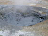
The area is amazing and interesting from every point. Fumaroles grow from the earth like small smoking hills. The black mud waters, are diverse, some are very liquid, others very dense ... but all of them make you think how all this diversity is possible in a reduced area. The rotthen egg smell is deep! Then for me it was also interesting to see how the lava color changes to indicate when the last eruption occured. The darker it is the closer in time the eruption happened.

Unfortunatelly my knowledge of geology is very poor so, in order to explain what is going on in this field, I have taken portions from the information centers at each place.

Namafall hverir is a "high temperature geothermal area with fumaroles and mud pots. At a depth of 1000m, the temperature is above 200ºC. Along with the steam comes fumarole gas, such as hydrogen sulfide which is responsible for the characteristic hot spring smell in these areas. The hot springs produce considerable sulphur deposits. In previouse centuries sulphur was mined in Iceland to produce gun powder" Extract from the information center at Namafall hverir.

Please read the notes at the information center once you are there. Walking is only allowed in marked areas since the temperature is very hot.


After Namafjall Hverir we headed to the Krafla Geothermal field. In order to better explain what Krafla is I will write an extract from the information center at Krafla:


"Iceland is part of the ocean floor which has been forced up above the sea level by special geological conditions. The "hot spot" located beneath Iceland has played a major role in this process, and one of the places it breaks forth is the Krafla geothermal field, where it is accesible for energy procurement. Nature's forces are still locked in battle and their conflicts take various forms: Steam from seething hot springs, volcanic craters of all shapes and sizes, large and small and rough and smooth streches of lava, the land split into fault blocks.

This area is a central vulcano. Primaveral forces tug the Earth's crust apart and split it with fissures that can be seen on the surface. Roughly 100km long, this fissure zone runs almost due north to Öxarfjördur fjord and south to Mt.Bláfjall. The land to the west and east of the fissures is continiously spreading apart in its respective directions, by an average of 2 cm a year. Stóragjá chasm is a clear example of such tectonic plate drifft. Some fissures have slipped to create a fault landscape Mt. Dalfjall, for example, was formed this way.

Volcanic eruptions are characteristic of such fissures. They create either crater series such as Threngslaborgir, or flow lavas of which Eldá is a fine example."..."


More than 10.000 years ago, this area was covered by an ice-age glacier. The ice hindered the lava from flowing away from the eruption fissure, and it piled up instead into tuff ridges such as Mt.Skogarmannafjöll. Mt.Búrfell, on the other hand, is a table mountain formed when the eruption managed to force its way through the surface of the glacier and fill the whole with lava. In some cases basic lava has formed under the glacier and been transformed into shiny obsidian. Hrafntinnuhryggur (Obsidian ridge) is an example of such phenomenon.


Almost all the hot pools that bubble way near Krafla are solfataras like Hverarönd. Hot strams do not flow from them, except underground - the bathing cave Grjotajá is a famouse instance(...)


One of most typical features of a central vulcano is a bowl shaped caldera which occurs in their centre. More than 100.000 years ago the centre of the vulcano around Leirhnjúkur sank or collapsed by several hundred meters in what must have been a spectacular eruption, to form a caldera some 8-10 km in diameter. Over the long period since then it has gradually filled up with pyroclastic material, lava and ash, which means that it has virtually vanished and can only be seen on carfull examination.


At a depth of 3-8 km beneath Leirhnjúkur is a magma chamber, full of molten lava (magma). At intervals of several centuries the lava forces its way out into the fissures or up to the surface in a fissure eruption, and the land spreads by several meters. Such activity can last for a long time, even as such as a decade, as happened in the eruption series of 1975 - 1984.

miércoles, 7 de mayo de 2008

Myvatn lake


The best experience around Iceland was around the Myvatn lake. Here we only stayed 2 days but it is worth spending many more days.


Myvatn is an area situated in the north east side of Iceland, close to the city of Akureyri. It is close to the Krafla Vulcano and has active vulcanic activity. The lake itself was created by a very big basaltic lava explosion. The lava explosions, when coliding with the water would form pseudocraters... they look like vulcanoes in shape!

We camped next to the lake area ... and the ground was warn. At that time we thought it was due to the hot weather we had during the day... but later on found out that the ground was warn due to the "recent" vulcanic activity going on below! One hint: the area is specially full of mosquitoes so if you go camping, remember to close well the tent!

In front of the camping there was a quite big supermarket where we bought the best bread I tried ever! It is called "hverabrauð" It is a typical bread of the Myvatn area, slowly backed with the natural heat found in the "underground earth" of the area.


Around Myvatn many activities can be done. We rented a bike and went around the lake. On the way we stopped by what is said to be the "Elfs Church" a cave with a particular shape at the entrance. During the trip there was a beautifull view over the lake and the pseudocraters!

One hint take water and food with you as it is difficult to find small shops to buy around the lake. We only found one and not very good.

In the afternoon we went to the hot spring of Jardbodin. It was really good and relaxing. I guess that people really go to the famouse blue lagoon in Reikyavik area and this one is not so popular but the waters are good and the view is ... interesting.


In the evening we prepared salmon with onions and potatoes on the grill. I have to addmit that in Iceland I have eaten the best salmon and lamb every in my life!.. I still dream about going back to iceland to taste it again. We even prepared food to go for the following day.

lunes, 5 de mayo de 2008

Visiting the Skalafellsjökull


We decided to take a trip to visit the top of the Skalafellsjökull (Glaciar). We meet the first bus at the bottom of the mountain, where we left our car. They took us up to the waiting point to the 4WD which would take us to the very top.


The journey was alltogether 1h aprox. It was a wonderfull experience! There it was obviously cold, very windy (I almost was not able to walk due to the strong wind) and the view was amazing. The shame was that you could really see the impact of the warming up there. They showed us how the landscape used to be and we saw how the glacier tonge has diminished in size.


The cafeteria was expensive and not very good.


/*-- Ana You Tube

*/

/*---Ana ---*/